Five-year mean 2006/07 - 2010/11: 19,408
Site conservation status
SPA (Upper Solway Flats and Marshes: selection stage 1.2)
Ramsar (Upper Solway Flats and Marshes: qualifying criterion 6)
NNR (Caerlaverock)
SSSI (various)
IBA (Upper Solway Flats and Marshes: criteria A4i, B1i, C3)
Site description and habitat
The flats and marshes of the Inner Solway Firth (NY1664) form one of the largest continuous areas of intertidal habitat in Britain. The main roosts are at Moricambe Bay at the confluence of the Rivers Waver and Wampool, on the Blackshaw and Priestside Banks between the channels of the Nith and the Annan Water, and on the extensive sandflats off the Rockcliffe saltmarsh. The latter comprises intertidal sand and mudflats and coastal saltmarsh formed between the Rivers Eden and Esk at the head of the Solway Firth.
The middle and upper reaches of the estuary form a large complex of interdependent resorts. The area amounts to over 10,000 ha and there are also more than 3,300 ha of saltmarsh. Most of the marsh, especially on the Cumbrian shore, is covered only by the highest tides, and is grazed in the summer by cattle and in the winter by sheep to a short sward which provides important feeding areas for the geese. The largest areas are at Rockcliffe and Burgh around the estuaries of the Eden and the Esk, at Caerlaverock between the channels of the Nith and Lochar, at Kirkconnel on the estuary of the Nith near Glencaple, and in Moricambe, Newton, Border, Calvo and Skinburness around the outfall of the Wampool and Waver.
Numbers and trends
Monthly dawn roost counts of the whole of the Inner Solway Firth (Mersehead to Grune point) have been carried out since 1987/88. Prior to that year counts were less co-ordinated and comprehensive. They reveal a steady increase from the 1960s to the mid 1990s, followed by a decline in the late 1990s. The maximum count recorded was 28,850 in March 1991 (Fig. 73). Feeding area counts proved very difficult due to the undulating landform creating large areas of ‘dead ground’. Counts are undertaken on neap tides on a dark phase of the moon to try to ensure that the geese are not pushed off by high tides at night or use moonlight to feed inland. It has become apparent, however, that Pink-footed Geese do roost inland, especially during periods of gales or when there is floodwater there. It is difficult to know if this is a recent occurrence or whether counting and a general awareness have brought this to our attention. For example, at Kirkbride, a field close to the village and about 1 km inland is used by Pinkfooted Geese in most years and it is clear that once the geese settle, they stay over night. Other records of inland roosts have been reported from the Eden Valley and the Esk near Longtown.
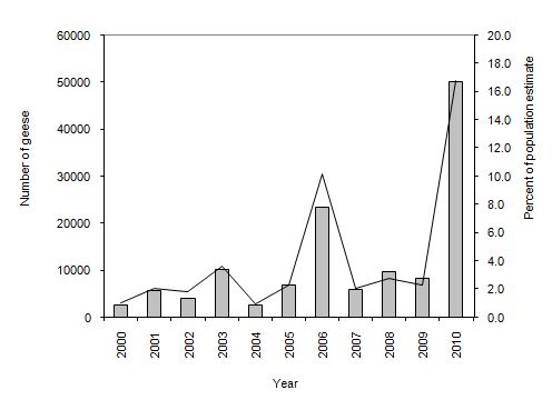
Figure 1. Maximum IGC counts of Pink-footed Geese on the Solway Estuary together with the count expressed as a percentage of the annual population estimate 2002 to 2010
IGC counts
| Season | October | November | December | Max winter count |
|---|---|---|---|---|
| 2002/03 | 3,401 | 2,213 | nc | 4,075 |
| 2003/04 | 2,609 | 3,398 | nc | 10,243 |
| 2004/05 | 247 | 2,612 | nc | 2,612 |
| 2005/06 | 890 | 1,244 | 3,150 | 6,862 |
| 2006/07 | 1,500 | 1,168 | 3,580 | 23,313 |
| 2007/08 | 5,793 | nc | nc | 5,793 |
| 2008/09 | 3,432 | 6,311 | 9,695 | 9,695 |
| 2009/10 | 7,700 | 8,295 | 7,484 | 8,295 |
| 2010/11 | 6,059 | 5,534 | 49,942 | 49,942 |
| 5 year Mean | 4,897 | 5,327 | 17,675 | 19,408 |
Table 1. IGC counts from October, November and December together with the highest count recorded during the winter season (often outwith the IGC montoring period).
Site use
The timing of peak numbers emphasises the strategic nature of the estuary with peaks recorded in both autumn and, especially, in the spring (Fig. 74), although autumn numbers have decreased in recent years. The counts show a very consistent pattern. From mid September to mid October the estuary is a brief stop-over for geese en route to Lancashire and, more recently, Norfolk. They feed mostly on the Scottish side roosting off Priestside and flighting over Priestside and Browell. The October count is rarely high. Usually very few remain into November and these numbers have declined in recent years. There tends to be a small increase in December, usually thought to be related to feeding conditions deteriorating further north in Scotland. Numbers begin to build up from mid to late January, and these too may involve Pink-footed Geese moving south from Scotland, as well as early movements north from Lancashire. February to early March is the peak period when the geese feed exclusively inland all round the estuary. Once the shooting season ends (20 February), the geese tend to move to the saltmarshes, especially in Moricambe Bay, Rockcliffe Marsh, Caerlaverock NNR and Kirkconnel Merse. Separate daytime counts have also been undertaken on Rockliffe Marsh since 1960 (Fig. 75). The Caerlaverock NNR (NY0464) takes in all the extensive intertidal flats lying between the rivers Lochar and Nith, together with the saltmarsh. For Pink-footed Geese this is the most important site on the Inner Solway (Fig. 76, also see above), reflecting the value of the reserve in reducing shooting and disturbance. Since the inception of the NNR in 1957, there has been carefully regulated shooting permit on part of the saltmarsh. A peak count of 25,000 birds was recorded there in January 1984.
There is some suggestion that the very rapid increase in the numbers of Svalbard Barnacle Geese using the estuary (to over 23,000 in the late 1990s) may be having a negative impact on the numbers of Pinkfooted Geese, although this is hard to quantify. The main feeding areas are on the farmland on either shore and on the saltmarshes, but they also extend inland, for example up Nithsdale and Annandale, for up to 20-25 km. The geese are regular, often in very large numbers, on the west shore of the Nith, both at Kirkconnel Merse (though rarely before the end of the shooting season, the peak numbers being in spring) and behind Southerness and along to Southwick Water. Feeding Pink-footed Geese may also be encountered along the south shore in suitable saltmarsh west towards Grune Point on the outer part of the estuary (NY1456, max 5,135 in March 1997).
On the landward side there are further feeding grounds which occupy the greater part of the coastal lowlands, notably in the stretch between Annan and Dumfries. There are further feeding areas along the Eden Valley, the Esk Valley and lowlands around Abbeytown and the Rivers Wampool and Waver.
For further information on Pink-footed Goose population levels visit the WWT species account pages (Pink-footed Goose)